 |
GPS SYSTEMS |
|
|
GPS SYSTEMS |
|
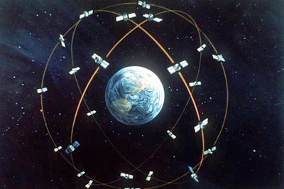
The (GPS) Global Positioning System is a satellite-based navigation system made up of an operational constellation consisting of 24 satellites placed into orbit by the U.S. Department of Defense. There are more than 24 satellits in orbit due to the fact that there are replacment satellites that are not yet in use. GPS was originally applied only in military applications, but in the 1980s, the government made the system available for the public to purchase and use.
 GPS satellites circle the earth every twelve hours in a very precise orbit. They transmit signal information to Earth via two microwave carrier signals. GPS receivers take these signals and use triangulation or trilateration to calculate the user's exact location. This works best if you can have the prefered number of six satellits sending their signals to your receiver. Basically, the receiver compares the time a signal was received to the time the satellite sent the signal. The time difference tells the receiver how far away the satellite is. Now, with distance measurements from at least two more satellites, the receiver can determine the user's position on the Earth. With four or more satellites in view, the receiver can determine the user's altitude, speed, bearing, path of movement, trip distance, distance to destination, and more.
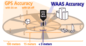 Today's GPS receivers are extremely accurate. Even in dense foliage or urban settings with taller buildings they can aqurie adequate signals. Certain atmospheric factors and other sources of error normally affect the accuracy of the receivers. Todays receivers without the government-imposed Selective Availability (SA) programs regulations are accurate to within approximately 15 meters. SA was intended to prevent military adversaries from using the highly accurate signals. The government turned off SA in May 2000, which significantly improved the accuracy of civilian receivers
If you want your receiver to be even more accurate make sure it contains WAAS (Wide Area Augmentation System), this capability can improve accuracy to less than an average of three meters. Users can also get better accuracy with DGPS (Differential GPS), which corrects the signals to within an average of three to five meters. The U.S. Coast Guard operates the most widely used DGPS correction service. This system consists of a network of towers that receives the signals and retransmits a corrected signal.
The first of the GPS satellites was launched in 1978, and it took another 16 years to get the system up to full power. The now 24 satellites that make up the space segment are orbiting the earth about 12,000 miles above us. They are constantly moving, making two complete orbits in less than 24 hours. These satellites are travelling at speeds of roughly 7,000 miles an hour. The satellites are powered by solar energy. They have backup batteries onboard to keep them running in the event of a solar eclipse. Small rocket boosters on each satellite keep them flying in the correct path. There is a constant resupply of GPS satellites going into orbit, due to the fact that they last only about 10 years.
GPS satellites transmit two low power radio signals, designated L1 and L2. Civilian GPS uses the L1 frequency of 1575.42 MHz in the UHF band. The military uses the L2 frequency. The signals travel by line of sight. A GPS signal contains three different bits of information: a pseudorandom code, ephemeris data, and almanac data. The pseudorandom code is simply an I.D. code that identifies which satellite is transmitting information. You can view this number on your unit's satellite page, as it identifies which satellites signal it's receiving. Ephemeris data, which is constantly transmitted by each satellite, contains important information about the status of the satellite (healthy or unhealthy), current date and time. This part of the signal is essential for determining the position of the receiver. The almanac data tells the receiver where each satellite should be at any time throughout the day. Each satellite transmits almanac data showing the orbital information for that satellite and for every other satellite in the system.

Top of Page --
Home--
GPS --
Accuracy --
GPS Satellite System
The Satellite Signal --
Sources of Signal Problems --
Printable Summary
Experimentation and Results --
Who We Are --
Project Sources